
A strengthening storm is expected to bring snow, ice, and possibly severe thunderstorms to parts of the central and eastern United States as it slides across the country this weekend into early next week.
AccuWeather expert meteorologists warn that several Arctic blasts will bring waves of bitterly cold air to much of the eastern half of the nation starting this weekend, which could result in the lowest January temperatures in more than a decade in some places.
“We’re going to be dealing with the coldest air of the season and multiple days of subzero temperatures from the northern Plains and Upper Midwest into the Tennessee Valley,” AccuWeather Chief On-Air Meteorologist Bernie Rayno said.

Cross-country storm
A storm barreling out of the Rockies will strengthen and create messy conditions that could impact millions of people this weekend through next Tuesday.
AccuWeather expert meteorologists warn that a battleground between the competing warm and cold air can produce freezing rain at times, complicating travel this weekend. This zone can quickly cause roads to become icy, making travel dangerous across the region. Any areas of excessive ice can down some tree branches and power lines, leading to localized power outages.
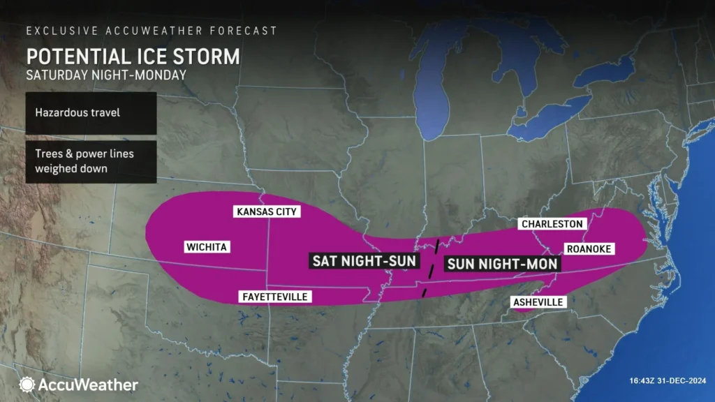
“There’s enough cold air on the northern side of this storm for accumulating snowfall,” Rayno said. “There’s a large zone from the Plains through the mid-Atlantic that could see a wintry mix with snow, ice, and rain that could create slippery travel conditions.”
Snowfall will begin across the Plains on Saturday, bringing slick road conditions and reduced visibility. Meanwhile, this storm is expected to deliver heavy rainfall and thunderstorms across Oklahoma, Texas, and the Gulf Coast.
Moisture from the Gulf of Mexico interacting with the passing storm will fuel thunderstorms on Sunday. AccuWeather expert meteorologists say thunderstorms can be severe with hail and damaging winds across the Gulf Coast states. The AccuWeather Local StormMax™ for Sunday and Sunday night is 70 mph.
There also is a risk of an isolated tornado. Severe thunderstorms on Sunday could impact areas that were recently damaged by tornadoes and damaging wind gusts.
The storm will continue to advance eastward, bringing travel concerns to the East. Snow and ice will arrive across the Ohio Valley and mid-Atlantic next Monday. Snow and freezing rain could impact morning commutes on Monday and Tuesday across the mid-Atlantic coast.
Originally appeared on AccuWeather


