


A white Christmas is looking more and more like it will be just a dream for a large chunk of the contiguous United States as the holiday nears, but there are a couple of pockets of the country that may get some last-minute help from Mother Nature just in time for Christmas.
With the holiday about a week away, meteorologists have been able to take a closer look at which places could have a white Christmas. Chances have remained consistent for many parts of the U.S. since AccuWeather’s initial outlook on Dec. 1, but in certain parts of the nation, there will be a decrease in the probability of a snowy Christmas as the Heat Miser may claim this year as a green Christmas.
AccuWeather’s criteria for a “white Christmas” centers around having at least an inch of snow on the ground for the holiday — a qualification that is difficult for many warmer locations in the U.S. even without a La Niña pattern present. This pattern, which originates with cooler-than-normal waters in the central and eastern Pacific around the equator, often drives an active storm track across the northern tier of the U.S. and leaves southern sections of the country drier than normal.

Areas across the southern U.S. won’t have much of a change with most places from Southern California to the Eastern Seaboard still likely to experience lower-than-normal chances for snow. Farther to the north, the once near-normal chances for snow across the central and southern Plains have dropped to lower-than-normal chances.
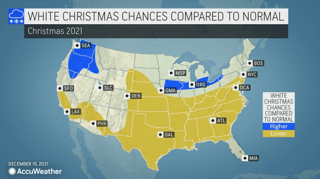
The lower odds in this region are due to “too much dry air in place” across areas like western Nebraska and Kansas for any snow to develop, AccuWeather Lead Long-Range Forecaster Paul Pastelok said. The dry zone will occur between active storm tracks, including one that will focus on the Rockies, another that will aim farther to the northeast across the Upper Midwest and finally storms that may move northward from the lower Mississippi Valley, Pastelok explained.
The East Coast was already forecast to have lower-than-normal chances of snow, but now chance in the central and southern Appalachians will drop as well as it may not be cold enough for snow to fall and remain on the ground in the aforementioned regions.
Near-normal probabilities are still expected in the Northeast, and in higher elevations, snow is likely to blanket the ground. However, a period of stormy and cold weather is possible near Christmas, which could result in rain and snow along the coast and accumulating snow farther inland.
Rain is still likely to overtake snow through Christmas in the Tennessee Valley to the lower Ohio Valley, making it difficult to keep any snow on the ground. However, just north, the chance remains that snow may fall along the southern shore of Lake Erie and stay for the holiday.
One major Midwest city that has faced a snow drought thus far this season is among those with higher-than-normal chances for a white Christmas. Chicago, a city known for its extreme cold and winter weather, hasn’t yet recorded a measurable snowfall this season. On average, Chicago records its first snowfall around Nov. 18, and Dec. 20 is the latest date on record. It could be a close call this year. However, that could soon change, and just in time for the holiday.


